Using Field Escort
For traffic-management, maintenance and safety staff, and anyone handed the map link. No login is needed for anything except the operator tasks in section 9.
Contents
- 1. Getting started
- 2. Reading the map
- 3. The machine popup
- 4. Signs, advisories and activations
- 5. Winter operations and plows
- 6. Rewind and history
- 7. The other layers
- 8. Is it working?
- 9. Operator tasks
- 10. When something looks wrong
- 11. Glossary
1. Getting started
Open purposebuilt.systems/field-escort/map in any modern browser, on a desktop, tablet or phone. The map refreshes itself every 60 seconds; there is nothing to reload.
- The panel on the left carries the headline count, the legend and the layer buttons. The − button tucks it away; on a phone it starts tucked away so the map gets the screen.
- The guided tour runs once on your first visit and can be reopened at any time with the ? button. It points at each control in turn and can skip a chapter at a time.
- Operating hours. The service reads the fleet from 6:00 AM to 5:30 PM Central. Outside those hours the map is empty by design, not by fault.
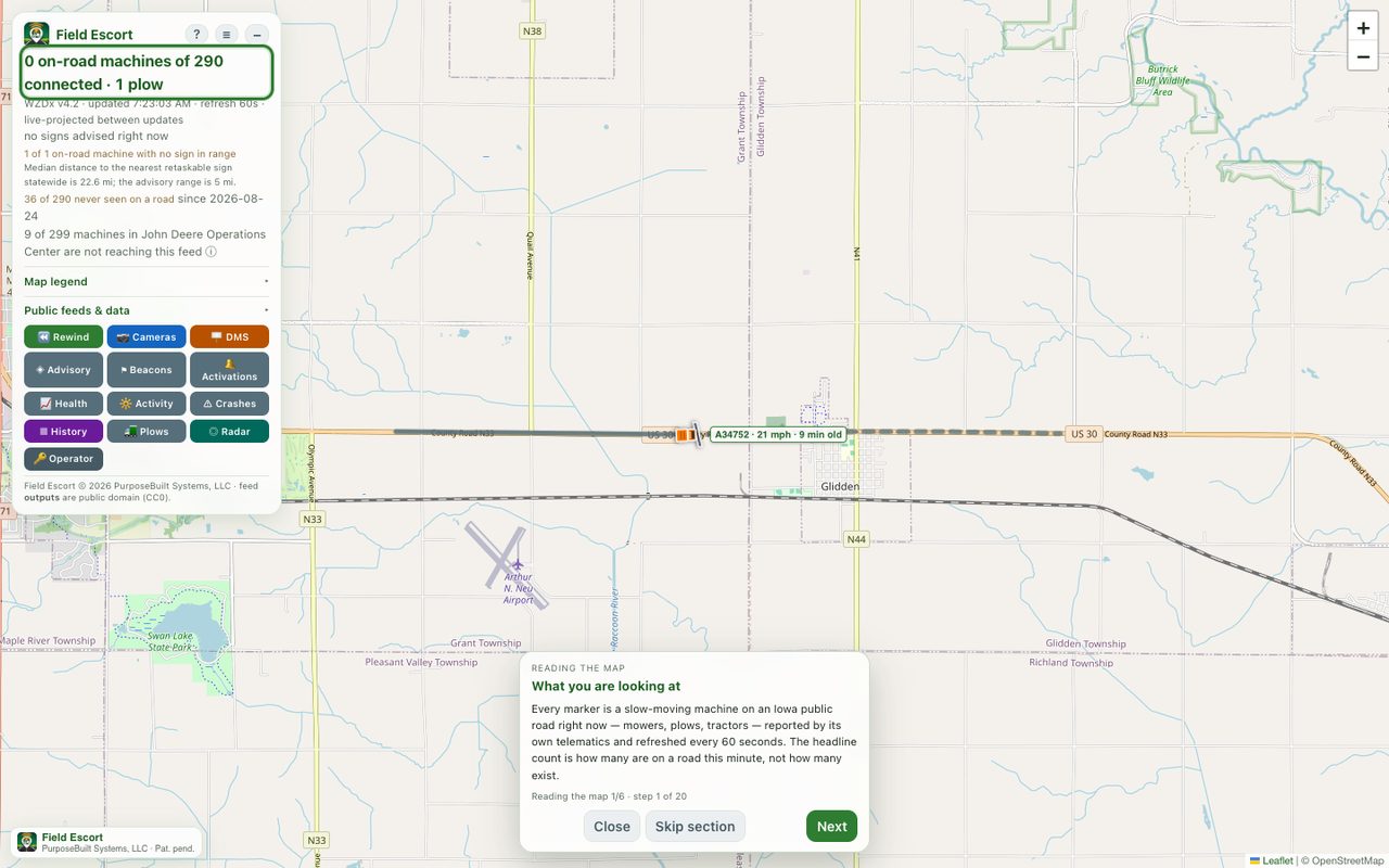
2. Reading the map
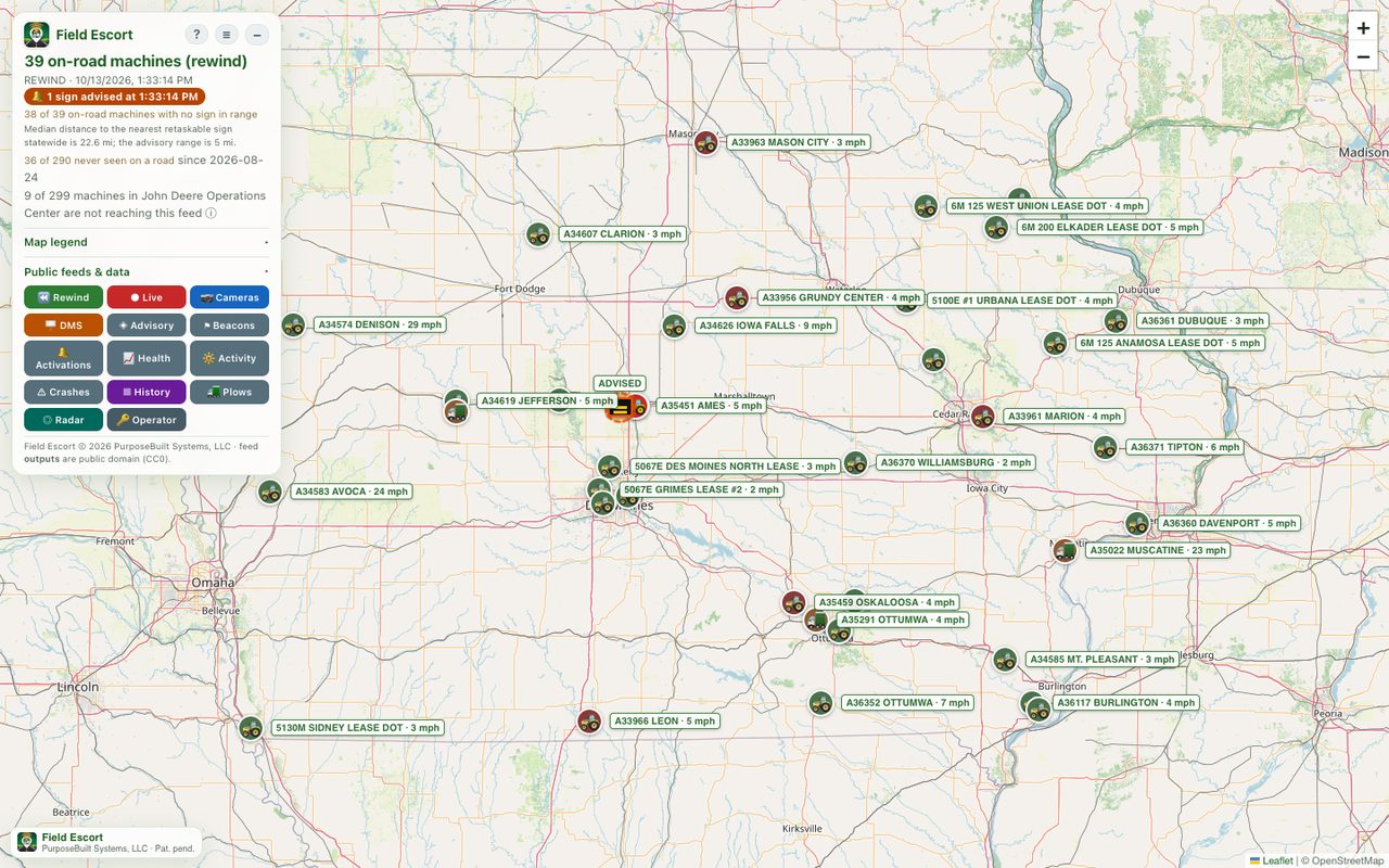
The headline
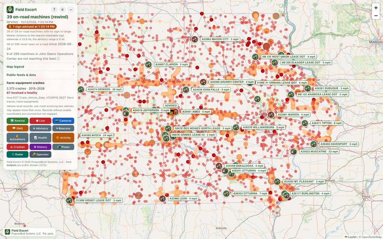
"39 on-road machines of 290 connected" is how many machines are on a public road this minute, out of the connected fleet. Snowplows are counted separately ("· 4 plows"), because they come from a different source.
Markers
- Equipment is drawn with its maker's icon. Snowplows are orange plow trucks, pointing the way they are heading.
- The marker is a calculation, not a fix. It sits where the machine is estimated to be now, advanced along the road from its last report by its speed and the time since. A machine working back and forth is advanced less than one in transit.
The line is a warning zone, not a trail
Solid marks the road just behind the machine: the stretch that matters to a driver closing on it. Dashed is the road ahead. Neither is where the machine has been.
When the road cannot be traced, or the machine is working back and forth, it is drawn as a dashed circle: "somewhere in here", with no direction claimed. Its description says so in plain words: slow-moving vehicle near US 30, or equipment working on IA 141.
Why most of the fleet is missing
Only a fraction of connected machines appear at once. The rest are held back on purpose: working in a field, in a yard or at a home, parked (under about 2 mph), travelling over 40 mph, or carrying a report more than 45 minutes old. Hiding field work is the privacy promise the service is built on.
3. The machine popup
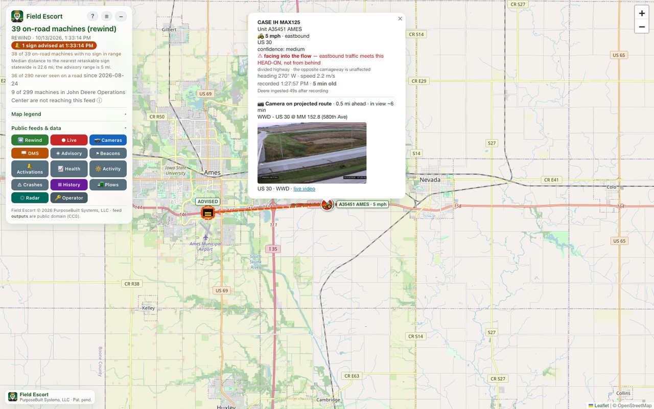
Click any machine. The popup shows:
- What and where: make and model, unit, speed, the direction of the traffic affected, and the road.
- Confidence: high, medium or low, from how old the last report is.
- Side of the road, once several reports agree, with the agreement, report count and distance off the centre line so you can weigh it. Where there is a lane to move into it adds what traffic should do: a machine on the right side means keep left. On a road with one lane each way no instruction is given, because "left" there is the oncoming lane.
- Head-on warning in red when the machine works against the flow of its carriageway (mowing a median, a shoulder pass). Closing speed is then the sum of both vehicles, not the difference.
- Report age and when it was recorded, and the nearest camera with a live still and a video link.
4. Signs, advisories and activations
Field Escort recommends; it does not control signs. Its advisories are published for a traffic-management system (advisories.json, and a TMDD feed) which applies its own rules and operator confirmation.
How a sign is chosen
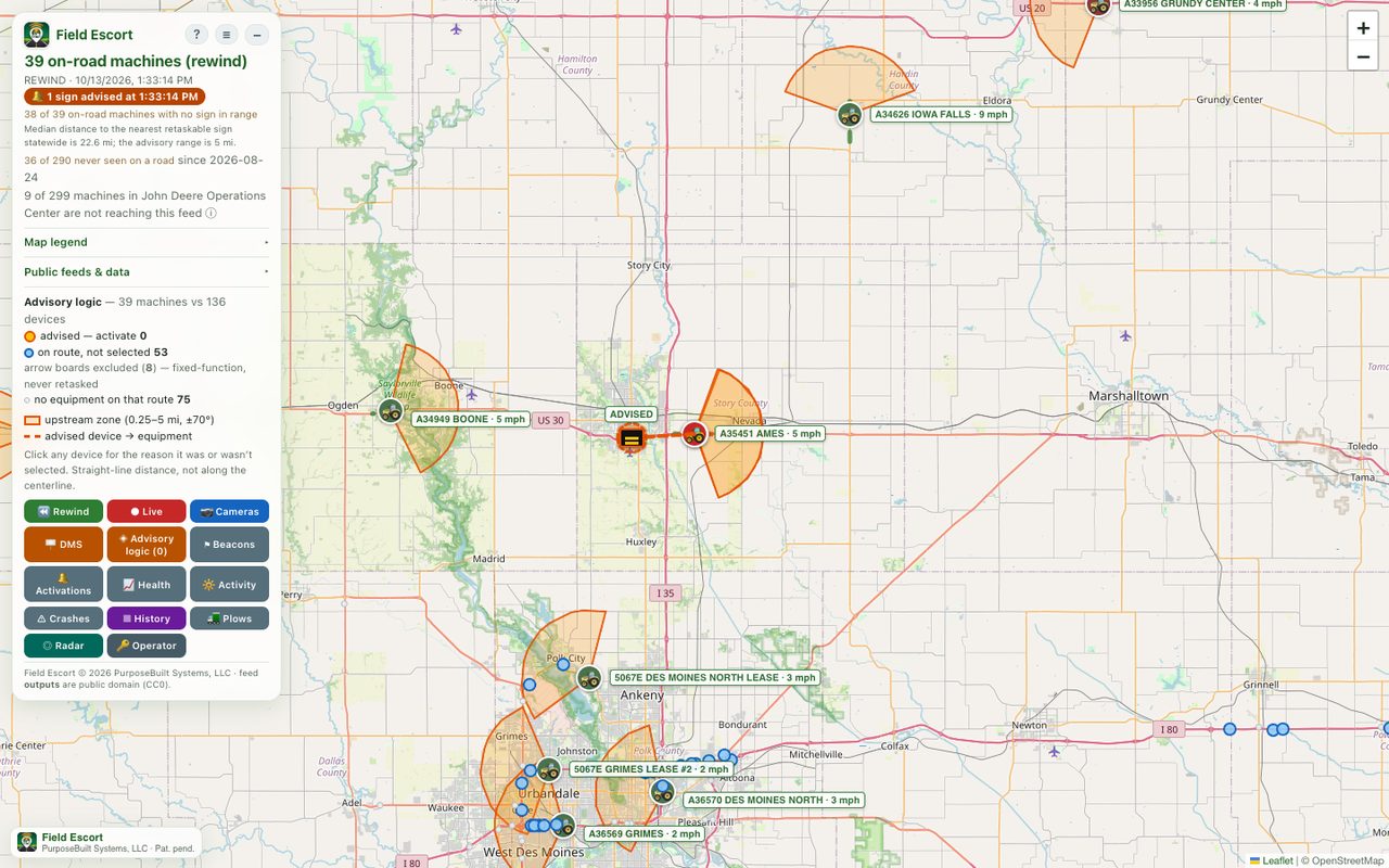
A sign is advised for a machine when all of these hold:
- it sits behind the machine, inside a wedge from 0.25 to 5 miles back and within ±70° of the reverse of its heading;
- it is on the same route and serves the same direction of traffic;
- it can show text (arrow boards are excluded: they are a contractor's own work-zone device).
Distance is measured along the road where the state's road reference allows, and straight-line otherwise; each advisory says which.
What the sign says
| Line | Copy |
|---|---|
| 1 | SLOW VEHICLE; in winter conditions SNOW PLOW for a plow, SNOW REMOVAL for other equipment |
| 2 | Distance: AHEAD or 3 MI AHEAD |
| 3 | Speed, 6 MPH, or KEEP LEFT / KEEP RIGHT where the side is known and two or more lanes run the driver's way |
Activations
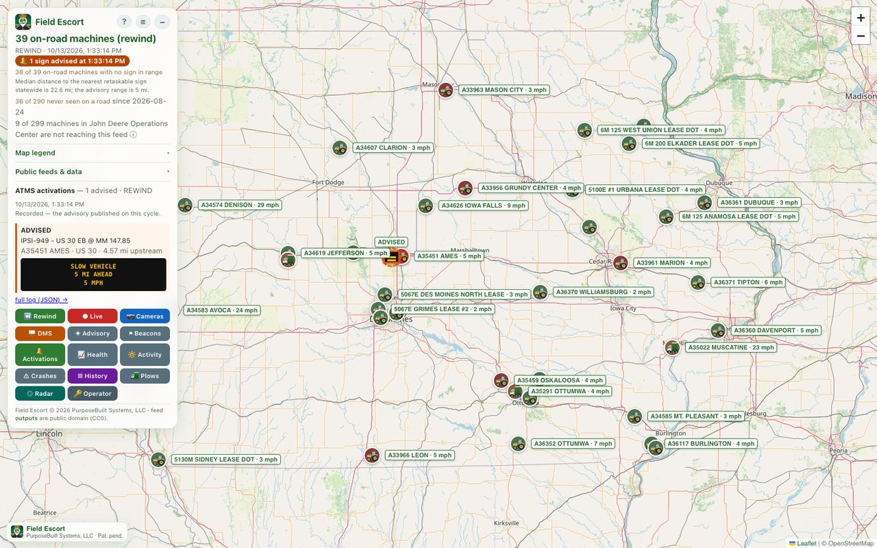
The Activations button opens the log of advisories raised and cleared. This is what to reconcile a radio call or a complaint against. The full history is kept for every day, at advisory-log.json.
5. Winter operations and plows
When signs switch to winter copy
Automatically, from the weather actually observed at the nearest National Weather Service station, never a forecast. A machine is in winter conditions when that station reports snow, sleet, ice or freezing precipitation, or any precipitation at 1 °C (33.8 °F) or colder. Temperature alone does not count: a truck on dry pavement at −1 °C is usually hauling, not plowing.
Cleanup outlasts the snowfall. The winter label holds for 6 hours after the last frozen observation, and then for up to a day more while the station stays at or below freezing, because snow does not melt off a cold road. A plow spreading salt or sand is labelled from its own sensors whatever the weather.
Snowplows
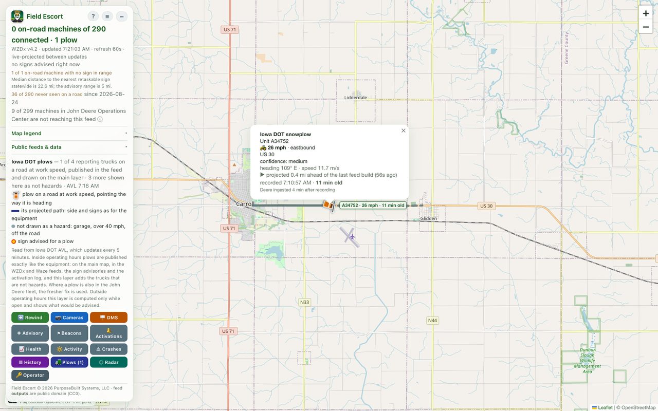
Plows come from the department's own AVL and go through the same rules as the equipment. Inside operating hours they are on the main map and in every feed. Some plows are also in the John Deere fleet under the same unit number; the map uses whichever report is newer, so a truck is never drawn twice. The Plows button adds the trucks that are not hazards (parked, in a garage, or travelling over 40 mph) and their blade and spreader readings. Outside operating hours it shows, on request, what would be advised.
6. Rewind and history
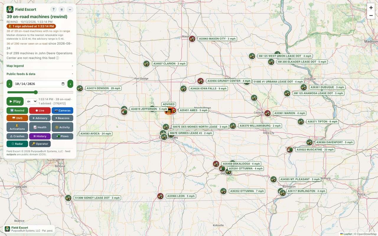
- Rewind replays any archived day a minute at a time, with the machines and the signs advised exactly as they were. Pick the day, drag the slider or press ▶ Play; the speed selector runs from 0.5× to 8×. Live returns to now.
- Advisories in a frame are marked recorded (what was published at the time) or reconstructed (rebuilt for days before advisories were archived, against today's sign inventory).
- History draws every published position from the last few hours as points.
7. The other layers
| Button | What it shows |
|---|---|
| Cameras | Public traffic cameras with a live still and video link. A machine popup always names the nearest one. |
| DMS | Every message sign, with the message it is displaying right now. |
| Advisory | Each machine's wedge and why every sign was or was not chosen (section 4). |
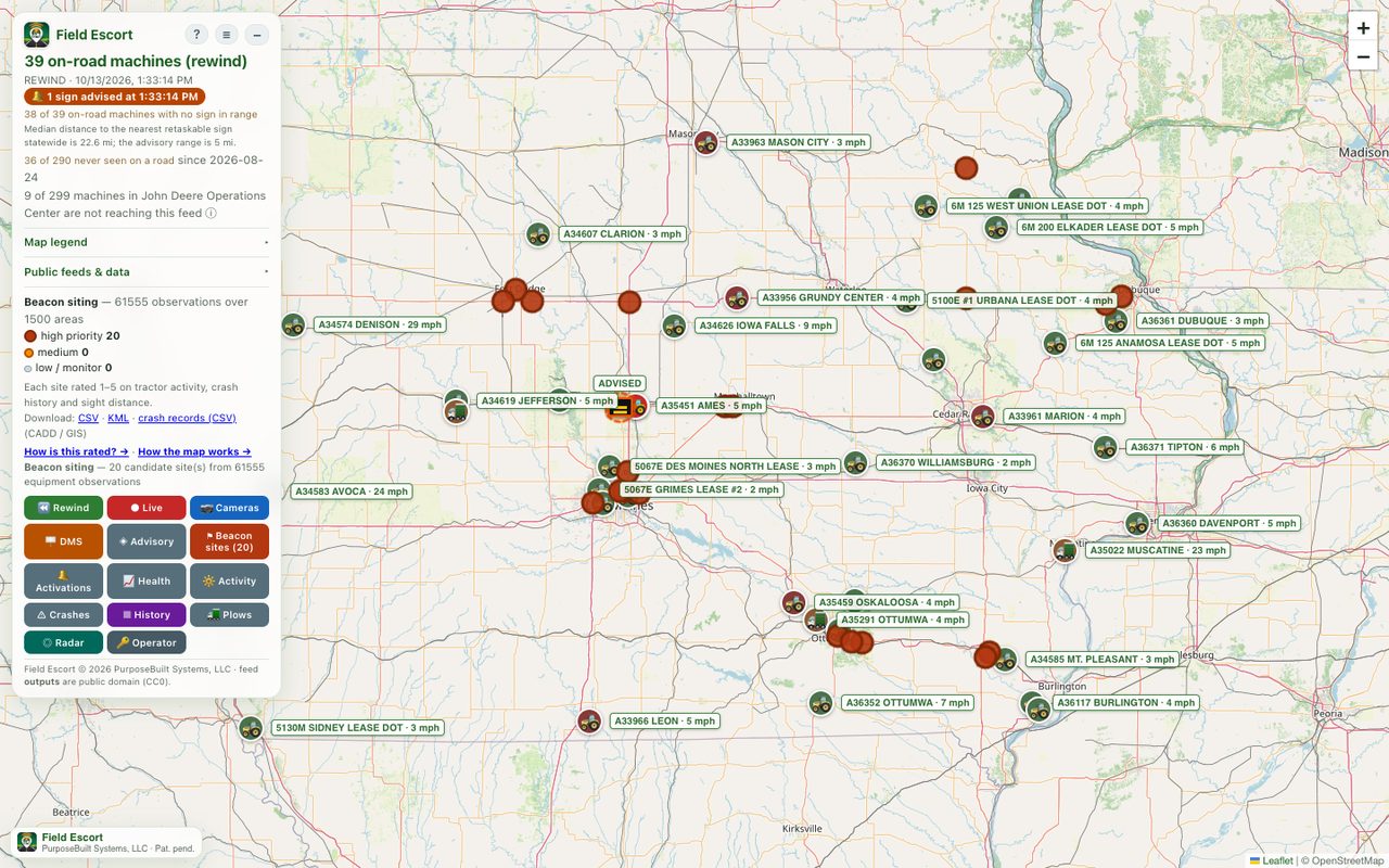
| Beacons | Candidate sites for a permanent warning beacon, each carrying the evidence behind its score. CSV, KML and crash-record downloads in the panel. |
| Activity | Where equipment works, from all recorded history. History answers where they went today; Activity, which roads carry this traffic at all. |
| Crashes | The farm-equipment crash record, fatal crashes larger and darker. Best viewed under Activity. |
| Health | The service scoring itself: position freshness and corridor accuracy (section 8). |
| Radar | Roadside radar sites recording what physically passes, independently of the equipment's telematics. |
8. Is it working?
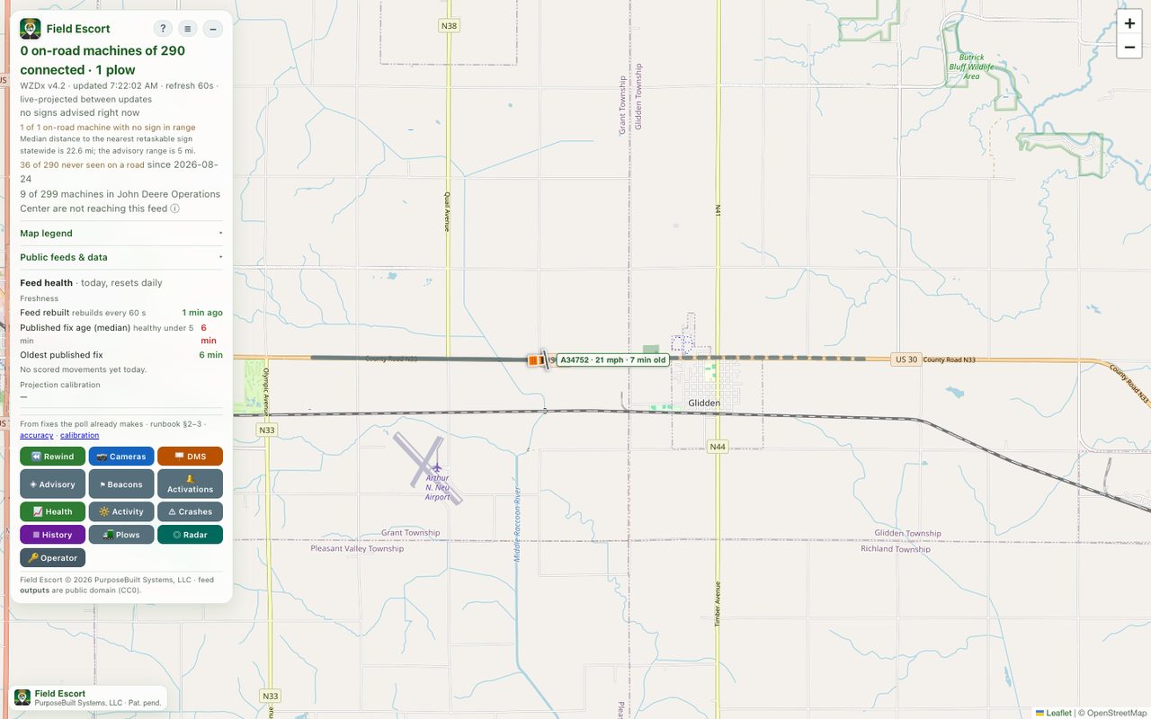
- Health shows how old published positions are and how often the drawn corridor contained the machine at its next report. If position ages are old and bunched together (29, 30, 30, 31 minutes), the service has stopped updating: call support.
- Feed availability shows how often the fleet read succeeded and how often a failure reached consumers as a blank feed. A brief upstream failure republishes the last good positions for up to five minutes rather than blanking the feed.
- Empty outside 6:00 AM–5:30 PM Central, or on a day the fleet is not working, is normal.
- No advisories is normal (section 4). To tell quiet from broken, open advisories.json: a non-zero devices_in_inventory means the sign list loaded and nothing is near enough to advise.
9. Operator tasks
These need the operator token. Keep it out of email and chat.
Diagnostic
Under Operator, paste the token and press Diagnostic to plot the whole fleet, including machines the privacy gate hides, coloured by why each was held back. It shows equipment in fields and yards: do not share screenshots of it.
Emergency stop
Stops all publishing within about a minute, without touching anything else. Set disabled=0 to resume.
curl -X POST -H "Authorization: Bearer <TOKEN>" \
  "https://purposebuilt.systems/field-escort/control?disabled=1"
Winter mode overrides
Automatic is the default and needs no action. Overrides expire on their own so they cannot be forgotten:
| Mode | Use it to | Lasts |
|---|---|---|
| snow | Declare a snow event the stations have not caught, optionally within an area (bbox=west,south,east,north) | up to 72 h |
| normal | Silence winter copy, for example when a station is misreporting | up to 7 days |
| default | Return to automatic | — |
curl -X POST -H "Authorization: Bearer <TOKEN>" \
  "https://purposebuilt.systems/field-escort/ops-mode?mode=snow&hours=12"
10. When something looks wrong
| You see | Most likely | What to do |
|---|---|---|
| Map empty, equipment is working | The road-check service is down and the feed is failing closed on purpose | Call support. The availability page can still read 100%: it measures the fleet read, not the road check. |
| Map empty early, late or on a weekend | Outside operating hours, or the fleet is not out | Nothing. |
| A machine drawn as a dashed circle | Road not traced, or the machine is working back and forth | Nothing: no direction is claimed on purpose. |
| Ages old and bunched together | The service stopped updating | Call support. |
| A sign advised that looks wrong | Open the Advisory layer and click the sign: it states why it was chosen | Report the sign and the time; Rewind shows the exact frame. |
| Winter copy on a dry road | Cleanup hold after a storm, or a station misreporting | Set normal (section 9) if it is the station. |
11. Glossary
| Advisory | A recommendation that a sign should warn about a machine. Not a command. |
| Activation | An advisory being raised; a clearance is it ending. |
| AVL | Automatic vehicle location: the plow trucks' own position reporting. |
| Corridor | The warning zone drawn along the road around a machine. |
| DMS | Dynamic message sign: a roadside board that can show text. |
| Operating window | 6:00 AM–5:30 PM Central, when the fleet is read and published. |
| WZDx | Work Zone Data Exchange, the US standard feed format for work zones. |
| Waze CIFS | The format Waze ingests incidents in. |
| Cleanup hold | Winter copy kept on after the snow stops: 6 hours, then while it stays at or below freezing, up to a day. |
Field Escort · PurposeBuilt Systems, LLC · Patent pending (US provisional 63/901,544). Screenshots from the public map, October 2026. Feed outputs are public domain (CC0).